
How to Build in the Hills: Navigating Los Angeles’ Baseline Hillside Ordinance
By Semone Kessler, Principal at Matter Architecture
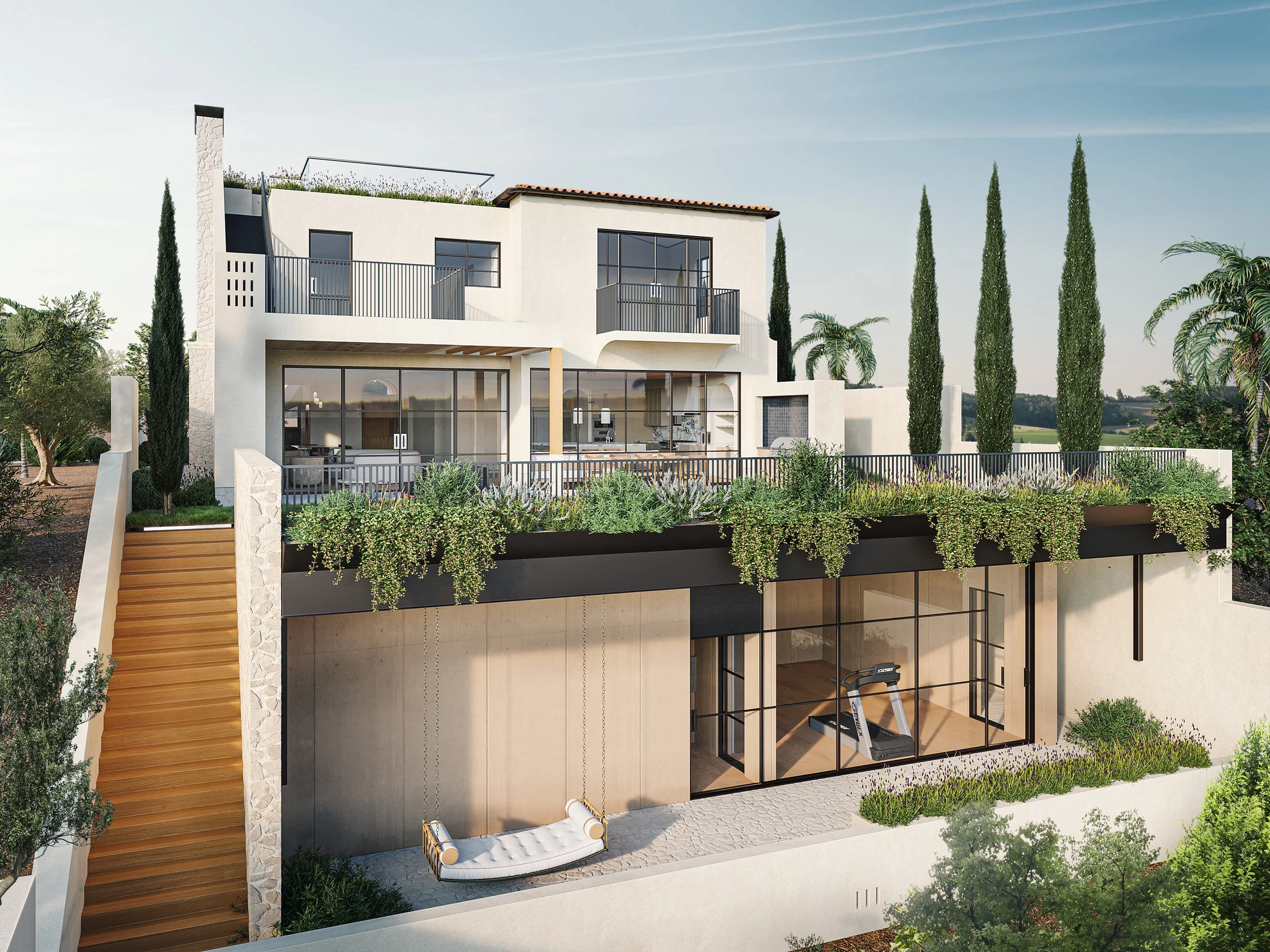
Fig. 1 Mount Holyoke project by Matter Architecture, a ground-up single-family residence in the Pacific Palisades and the project these notes are inspired by.
In Los Angeles, there are two kinds of people: ocean lovers and canyon kids. I'm the latter. One of the most incredible things about Los Angeles is the canyons and hills. I actually grew up in the Beverly Glen canyon and have always been drawn to hillside living. Nothing beats going to sleep to the sound of owls and coyotes howling and waking up to the quiet rustling of the trees. It feels like you're in the country, but you can hop down to some of the coolest restaurants and concerts on earth.
The only problem is, hillside construction is deeply complex. There's no doubt about it — but we think the juice is worth the squeeze. So I'm going to walk you through how to navigate building on your hillside lot. Buckle up.
Everyone starts researching a hillside lot the same way. Pull ZIMAS, confirm the Hillside Area designation, order the slope analysis, run the Residential Floor Area calculation, and find out how big the house can be.
That's the right first move. It's also, on most hillside lots, the wrong answer to the question.
On a hillside lot, RFA tells you how much house the code permits. Grading tells you how much house the site can deliver. These are usually different numbers, and the second one is smaller. On Mount Holyoke — a new single-family residence we are the architects on — the earthwork budget, the access condition, and the slope-dependent height envelope did more to shape the building than the floor area cap itself.
Here's the constraint stack, in the order we think it should actually be run.
0. A note on the numbers you've read
Most of what's online about the Baseline Hillside Ordinance describes the 2011 version. Ordinance No. 184,802 amended it, and several of the headline numbers changed. If you are working from an article, a broker's summary, or a blog post written before 2017, verify every figure. Specifically:
| Provision | Frequently cited (2011) | Current |
|---|---|---|
| Guaranteed Minimum RFA floor | 1,000 SF | 800 SF or the zone percentage, whichever is greater |
| RFA bonus eligibility | All single-family zones | RA, RE and RS zones only — R1 is not eligible |
| Number of bonus options | 7 | 6 |
| Base grading quantity | 500 CY + 5% of lot size | 1,000 CY + 10% of lot size, subject to a by-right cap by zone |
The controlling document is LAMC §12.21 C.10. The most usable version is City Planning's checklist, CP-4061 — Hillside Area Development Standards, Single Family Zone, which reproduces every table in the ordinance and is the form a planner will use on your project.
- CP-4061 Hillside Area Development Standards (Single Family Zone)
- LAMC via American Legal
- LADBS Baseline Hillside Ordinance Correction Sheet
1. Confirm what you're actually in
Hillside Area designation is the trigger, but it is not the only overlay that governs earthwork and massing. Before anything else, confirm on ZIMAS:
- Hillside Area designation. Generally areas with natural slopes of 15% or greater. The "H" suffix in the zoning string is the tell, but read the ZIMAS report rather than the string alone.
- HCR — Hillside Construction Regulation District (LAMC §13.20). A separate and more restrictive overlay layered on top of the BHO. It caps grading at the lesser of the by-right maximum or 6,000 CY, cuts import/export to 75% of by-right on substandard streets, and limits hauling to four truck trips per hour. If you are in HCR, the BHO number is a ceiling you will not reach.
- Coastal Zone, Specific Plans, HPOZ. These take precedence over the BHO on setbacks and height.
- NELA and Oaks of Los Feliz. Different checklists entirely, per §12.21 C.10(l)(4) and (5).
- Substandard Hillside Limited Street frontage. More on this below — it is the sleeper item.
Flag: HCR boundaries have been amended more than once. Confirm current status with Planning rather than assuming from an older map.
2. Run the RFA — but know what it's worth
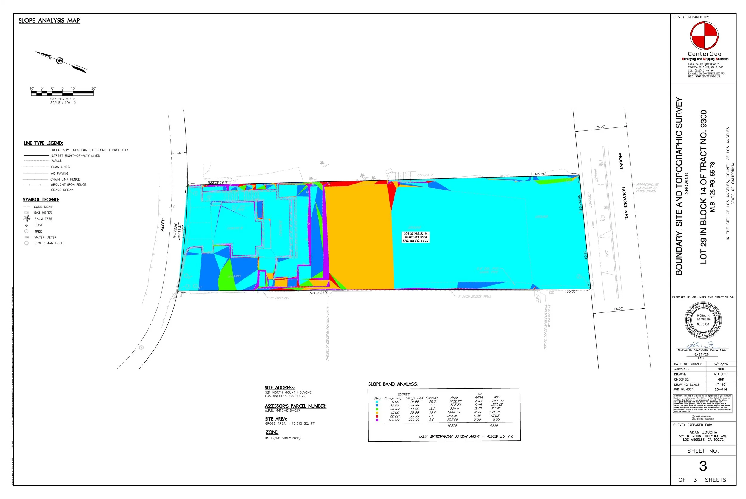
[IMAGE: Slope Band Analysis — Mount Holyoke]
The above image is our Slope Band Analysis done for Mount Holyoke.
Per §12.21 C.10(b)(1), the Slope Analysis Map must be prepared, stamped and signed by a registered civil engineer or licensed land surveyor, at a scale not less than 1" = 100' with a contour interval no greater than 10 feet and 2-foot intermediates, produced in CAD or GIS. This is not a back-of-napkin exercise you can carry into plan check. Budget for it in the survey scope at the outset.
The RFA is the sum of each slope band's area multiplied by its Residential Floor Area Ratio. Current R1 ratios, per Table 12.21 C.10-2a:
| Slope Band | R1 RFAR |
|---|---|
| 0 – 14.99% | 0.45 |
| 15 – 29.99% | 0.45 |
| 30 – 44.99% | 0.40 |
| 45 – 59.99% | 0.35 |
| 60 – 99.99% | 0.30 |
| 100%+ | 0.00 |
The alternative is the Guaranteed Minimum under §12.21 C.10(b)(2): the zone percentage of lot size (R1 = 25%) or 800 SF, whichever is greater.
The procedural item people miss: the result has to be verified on the Department of Building and Safety / City Planning Joint Referral Form — Slope Analysis and Maximum Residential Floor Area Verification Form, signed by DCP staff. That's a counter appointment and a calendar item, not a drawing note. Build it into the pre-submittal schedule.
3. Grading — the number that actually governs
Under §12.21 C.10(f)(1), cumulative grading — cut and fill combined, not net — is limited to 1,000 CY plus 10% of lot size in cubic yards. Then Table 12.21 C.10-6 caps it by zone:
| Zone | Max grading, standard or substandard hillside street (CY) | Max import/export, substandard street frontage (CY) |
|---|---|---|
| R1 | 1,000 | 750 |
| RS | 2,200 | 1,650 |
| RE9 | 2,400 | 1,800 |
| RE11 | 2,800 | 2,100 |
| RE15 | 3,200 | 2,400 |
| RE20 | 4,000 | 3,000 |
| RE40 | 6,600 | 4,950 |
| RA | 3,600 | 2,700 |
Read those two provisions together and something falls out that is worth saying plainly:
In R1, the formula is irrelevant. The base is 1,000 CY, the 10% adder is real, and the cap is 1,000 CY. An R1 hillside lot gets 1,000 cubic yards by right regardless of whether it's 5,000 SF or 15,000 SF. Lot size buys you floor area. It does not buy you earthwork.
One thousand cubic yards is not much. A modest pad cut, a driveway, utility trenching, retaining wall footings, and a pool will consume it. Exceed it and you are into a Zoning Administrator approval under §12.24 X.28 and — depending on export volume — a haul route approval requiring a public hearing before the Board of Building and Safety Commissioners. That is months, not weeks, and it is a public process with neighbors in the room.
The exemptions are a design strategy, not a footnote
§12.21 C.10(f)(3) exempts specific activities from the grading count. These are the levers:
- Deepened foundation systems — caissons and piles — provided no freestanding retaining walls are involved. This is the big one. A pile-supported structure that steps down the slope can cost less in earthwork budget than a cut pad, even when it costs more in structure. Run that trade study before the design locks, not after.
- Driveway cut and fill up to 500 CY to the required parking or fire department turnaround.
- Remedial grading recommended in a geotechnical report prepared per LAMC §§91.7006.2, .3 and .4 and approved by the Grading Division.
- Fill derived from cut under the main building footprint, up to 50% of that cut. Balanced site design is worth real cubic yards.
Note the trap in the preamble: excavation from an exempt activity that gets used as fill outside a five-foot perimeter of that activity counts against the limit anyway. You cannot launder soil through an exemption.
Separately: all new graded slopes are limited to 2:1 (horizontal:vertical) unless the Grading Division approves steeper per §91.105, and no grading permit issues until the building permit is approved.
4. Access — the constraint nobody checks early enough
This one is worth its own line in the feasibility memo, because it is binary and it is discovered late.
Under §12.21 C.10(i), if the lot fronts a Substandard Hillside Limited Street:
- No building or grading permit issues unless at least half the street width is dedicated across the full lot frontage to Standard Hillside Limited Street dimensions, or a lesser width per the City Engineer (§12.21 C.10(i)(1)).
- If the roadway is improved to less than 20 feet, no permit issues without a Zoning Administrator approval under §12.24 X.28 (§12.21 C.10(i)(2)).
- If there is no 20-foot continuous paved roadway from the driveway apron to the boundary of the Hillside Area, same result (§12.21 C.10(i)(3)).
And it cascades into massing and parking:
- No portion of the building within 20 feet of the front lot line may exceed 24 feet in height, measured from the street centerline or midpoint (§12.21 C.10(d)(5)).
- Above 2,400 SF of RFA, one additional parking space per 1,000 SF increment, to a maximum of five on site (§12.21 C.10(g)(2)).
- Elevated stairways, porches, platforms and landings may not project into the front yard at all.
Substandard Hillside Limited Street status is determined by the Bureau of Engineering. Get the determination in writing early. A dedication requirement discovered in plan check is a redesign, not a correction.
5. Height — two tests, not one
[IMAGE: Height Projection Elevation — Mount Holyoke]
The above image is our height projection elevation for Mount Holyoke.
Hillside height is not the flat-lot method. Two things have to be drawn:
Envelope height (§12.21 C.10(d)(1)) is plumb-line height measured from Hillside Area Grade to a plane at the roof or parapet directly above and parallel to grade, originating at the exterior walls. Every section of the building has to comply independently — there is no averaging.
Per Table 12.21 C.10-4, in R1, Height District 1/1L/1VL: 33 feet where the uppermost roof slopes 25% or greater, 28 feet where it slopes less than 25%. Height District 1XL is 30/28. In a 1SS Single-Story district it is 22/18 and one story, full stop.
That five-foot delta between a sloped roof and a flat roof is a real design decision on a tight envelope, and it is one of the few places the ordinance rewards a pitched roof.
Encroachment plane (R1) originates 20 feet above existing or finished grade — whichever is lower — along the required front and side yard setbacks, at 45 degrees. Show it on the elevations. It is a standard correction when it's missing.
Also worth knowing: unenclosed cantilevered balconies with visually permeable railing may project up to five horizontal feet beyond the envelope, per §12.21 C.10(d)(6). On a downslope lot that's usable outdoor area the ordinance hands you.
6. And then there's the pool
Two things, quickly, because Mount Holyoke has one.
It counts against your grading budget. Pool excavation is grading. It is not on the §12.21 C.10(f)(3) exemption list. On an R1 lot working against a 1,000 CY ceiling, the pool needs to be in the earthwork calculation from schematic design, not added at the end.
It cannot go in a required yard. Per §12.21 C.10(a)(12), no pool, pond, or body of water 18 inches or more in depth is permitted in any required yard space where fences over 42 inches are prohibited — and that applies even where the vessel sits below adjacent natural grade.
Third thing, worth its own article: a residential pool permit is typically a structural-only permit. It approves the shell. Hydraulic design, filtration sizing, equipment specification, CEC Article 680 bonding, Title 24 §110.4 equipment compliance, and LAMC §112.02 equipment noise are all outside that review. "The pool is permitted" and "the pool is designed" are different sentences.
The order we'd run it
- ZIMAS — Hillside designation, HCR, overlays, height district, street condition
- Bureau of Engineering — Substandard Hillside Limited Street determination, in writing
- Survey and Slope Analysis Map — stamped, per §12.21 C.10(b)(1)
- Preliminary earthwork budget against the zone cap — before massing
- Geotechnical investigation — including the foundation strategy trade study, piles vs. pad cut
- RFA calculation and DCP Joint Referral Form verification
- Envelope height and encroachment plane study
- Design
Most feasibility work runs 1, 3, 6, then designs. Moving the earthwork budget to step 4 is the single change that has saved us the most redesign.
Note: Code section references are to LAMC §12.21 C.10 as amended by Ordinance No. 184,802, and to CP-4061 dated 2/14/2020. The ordinance and the checklist are both revised periodically — verify current versions before relying on any figure here.
Note: This reflects our reading of the code. LADBS and City Planning staff interpretation may differ from ours, and several provisions in this article are subject to Zoning Administrator discretion.
Note: Northeast Los Angeles Hillside Area and the Oaks of Los Feliz are governed by separate standards and separate checklists.
Note: Nothing here substitutes for a stamped slope analysis, a geotechnical investigation, or an actual plan check.
Matter Architecture — matter.la